伊利諾伊州
美利堅合眾國下轄州
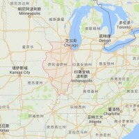
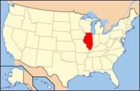
伊利諾伊州(Illinois)位於美國中西部,北接威斯康星州,東北瀕密歇根湖,東界印第安納州,東南鄰肯塔基州,西隔密西西比河與密蘇里州和艾奧瓦州相望。面積14.6萬平方公里,首府斯普林菲爾德(Springfield)。
該州別名“內陸帝國” (The Inland Empire)或“草原之州” (The Prairie State)。州花是紫羅蘭(Native Violet)。州鳥是北美紅雀(Cardinal)。州樹是白橡(White Oak)。
伊利諾伊州
伊利諾伊州(Illinois, IL)面積15萬平方公里(全美排名第25位),人口1283萬(2010年人口統計數據),在50州內列第5位,其中2/3居住在芝加哥及其周圍地區,白人、黑人和亞太裔分別佔總人口的71.5%、14.5%和4.6%,約有華僑華人10餘萬人。
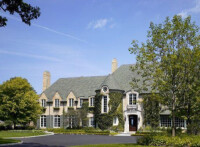
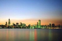
首府春田市(Springfield),位於伊州中部,人口11萬,是伊州的政治中心。芝加哥市(Chicago)是該州最大城市,地處伊州東北角,人口289萬,為美國第三大城市和重要的工業、金融、農產品加工和交通中心。城市高層建築頗具特色,被譽為“世界建築博物館”。
伊州2011年GDP6723億美元,人均GDP52116美元(全美排名第13位)。2011年對外貿易額1870億美元,佔全美外貿總額的5%,其中對華貿易額268.71億美元,出口額38.97億美元,進口額229.74億美元。
伊州是美國傳統製造業中心,主要產品為機械設備、農業機械、行動電話、醫療器械及農產品等。2009年《財富》雜誌評出的美國500家最大公司中有31家的總部設在伊州,在全美各州中位居第4。經濟外向型特徵明顯,1/7就業人口與出口有關。伊州也是農業大州,有農場7.8萬多個,農業人口佔全州總人口的2.7%,產值占州年生產總值的2%。
教育、文化和新聞事業發達。共有報紙700多份,其中日報50份,主要有《芝加哥論壇報》和《芝加哥太陽時報》。有50餘家電視台,近400家電台。大專院校188所,數量居全美第5位,在校生75萬人,其中芝加哥大學和西北大學綜合排名位列全美前十位左右。
伊州與遼寧省(1982年)和台灣省(1992年)互為友好省州,芝加哥與瀋陽(1985年)和上海(1985年)互為友城。此外,喬利埃特(Joliet)、洛克福特(Rockford)、柏林布魯克(Bolingbrook)、佩里亞(Peoria)、蓋利斯伯格(Galesburg)分別與遼寧省遼陽市、江蘇省常州市、河南省許昌市、遼寧省本溪市和安徽省馬鞍山市互為友城。
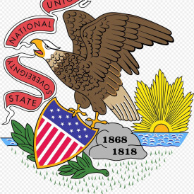
州徽
重要城市:芝加哥、埃文斯頓、埃爾金、奧克朗、喬利矣特、奧羅拉、沃其根、羅克福德、迪卡爾布、羅克艾蘭、蓋爾斯堡、皮奧里亞、諾黙爾、厄巴納-香檳、丹維尓、特雷霍持,印第安納州、斯普林菲爾德州府、布盧明頓、迪凱持、奧爾頓、東聖路易斯、森特勒利亞、卡本代爾、帕度卡,肯塔基州。
| County | FIPS code | County seat | Established | Origin | Etymology | Population | Area | Map |
| Adams County | 001 | Quincy | 1825 | Pike County | John Quincy Adams(1767–1848), sixthPresident of the United States | 67,103 | 857sqmi (2,220km) | |
| Alexander County | 003 | Cairo | 1819 | Union County | William M. Alexander, a settler and state representative in theIllinois General Assembly | 8,238 | 236sqmi (611km) | |
| Bond County | 005 | Greenville | 1817 | Crawford County, Edwards County, and Madison County | Shadrach Bond(1773–1832), FirstGovernor of Illinois | 17,768 | 380sqmi (984km) | |
| Boone County | 007 | Belvidere | 1837 | Winnebago County | Daniel Boone(1734-1820), trailblazer of theWilderness Roadin Kentucky | 54,165 | 281sqmi (728km) | |
| Brown County | 009 | Mount Sterling | 1839 | Schuyler County | Jacob Brown(1775–1828), a successfulAmerican Revolutionarmy officer responsible for Great Lakes defenses | 6,937 | 306sqmi (793km) | |
| Bureau County | 011 | Princeton | 1837 | Putnam County | Pierre de Bureo, Frenchman,North American fur trader | 34,978 | 869sqmi (2,251km) | |
| Calhoun County | 013 | Hardin | 1825 | Pike County | John C. Calhoun(1782–1850),South Carolinasenator and seventhVice President of the United States | 5,089 | 254sqmi (658km) | |
| Carroll County | 015 | Mount Carroll | 1839 | Jo Daviess | Charles Carroll of Carrollton(1737–1832), signed theDeclaration of Independenceon behalf ofMaryland | 15,387 | 444sqmi (1,150km) | |
| Cass County | 017 | Virginia | 1837 | Morgan County | Lewis Cass(1782–1866), second governor ofMichigan Territory, fourteenthUnited States Secretary of War | 13,642 | 376sqmi (974km) | |
| Champaign County | 019 | Urbana | 1833 | Vermilion County | Champaign County, Ohio, which took its name from theFrenchfor "open level country" | 201,081 | 997sqmi (2,582km) | |
| Christian County | 021 | Taylorville | 1839 | Sangamon County | Christian County, Kentucky, which was itself named afterColonel William Christian | 34,800 | 709sqmi (1,836km) | |
| Clark County | 023 | Marshall | 1819 | Crawford County | George Rogers Clark(1752–1818), highest-ranking officer in theNorthwest Territoryduring theAmerican Revolution | 16,335 | 502sqmi (1,300km) | |
| Clay County | 025 | Louisville | 1824 | Wayne, Lawrence, Fayette, and Crawford County | Henry Clay(1777–1852), Kentucky legislator who negotiated theMissouri Compromise | 13,815 | 469sqmi (1,215km) | |
| Clinton County | 027 | Carlyle | 1824 | Washington, Bond, and Fayette County | DeWitt Clinton(1769–1828),Governor of New York, responsible for the construction of theErie Canal | 37,762 | 474sqmi (1,228km) | |
| Coles County | 029 | Charleston | 1830 | Clark and Edgar County | Edward Coles(1786–1868), secondGovernor of Illinois, responsible for the abolition of slavery in Illinois | 53,873 | 508sqmi (1,316km) | |
| Cook County | 031 | Chicago | 1831 | Putnam County | Daniel Pope Cook(1794–1827), politician and firstAttorney General of Illinois | 5,194,675 | 946sqmi (2,450km) | |
| Crawford County | 033 | Robinson | 1816 | Edwards County | William H. Crawford(1772–1834), ninthUnited States Secretary of War, seventhSecretary of the Treasury | 19,817 | 444sqmi (1,150km) | |
| Cumberland County | 035 | Toledo | 1843 | Coles County | Disputed:Cumberland Road, which entered the county;Cumberland, Maryland; orCumberland Riverin Kentucky | 11,048 | 346sqmi (896km) | |
| DeKalb County | 037 | Sycamore | 1837 | Kane County | Johann de Kalb(1721–80), German soldier in theContinental Armywho fought alongsideGilbert du Motier, marquis de Lafayette | 105,160 | 634sqmi (1,642km) | |
| DeWitt County | 039 | Clinton | 1839 | Macon and McLean County | DeWitt Clinton(1769–1828),Governor of New York, responsible for the construction of theErie Canal | 16,561 | 398sqmi (1,031km) | |
| Douglas County | 041 | Tuscola | 1859 | Coles County | Stephen A. Douglas(1813–61), prominent Illinois Democrat whoengaged in debateswithAbraham Lincoln | 19,980 | 417sqmi (1,080km) | |
| DuPage County | 043 | Wheaton | 1839 | Cook County | DuPage River | 916,924 | 334sqmi (865km) | |
| Edgar County | 045 | Paris | 1823 | Clark County | John Edgar(c. 1750–1832), Illinois delegate to theNorthwest Territorylegislature; at time, wealthiest man in Illinois | 18,576 | 624sqmi (1,616km) | |
| Edwards County | 047 | Albion | 1814 | Gallatin County and Madison County | Ninian Edwards(1775–1833), thirdGovernor of the State of Illinoisand only governor of theIllinois Territory | 6,721 | 222sqmi (575km) | |
| Effingham County | 049 | Effingham | 1831 | Fayette and Crawford County | Lord Thomas Effingham, military officer who resigned from theBritish Armyto avoid fighting the American colonies | 34,242 | 479sqmi (1,241km) | |
| Fayette County | 051 | Vandalia | 1821 | Bond, Wayne, Clark, Jefferson, and Crawford County | Marquis de la Fayette(1757–1834), French military officer who was a key factor in theAmericanandFrench Revolutions. | 22,140 | 716sqmi (1,854km) | |
| Ford County | 053 | Paxton | 1859 | Vermilion County | Thomas Ford(1800–50), eighthGovernor of Illinois; served during theIllinois Mormon War | 14,081 | 486sqmi (1,259km) | |
| Franklin County | 055 | Benton | 1818 | White County and Gallatin County | Benjamin Franklin(1706–90), prolific writer, inventor, and politician; key factor in theAmerican Revolution | 39,561 | 412sqmi (1,067km) | |
| Fulton County | 057 | Lewistown | 1823 | Pike County | Robert Fulton(1765–1815), inventor of thesteamboat | 37,069 | 866sqmi (2,243km) | |
| Gallatin County | 059 | Shawneetown | 1812 | Randolph County | Albert Gallatin(1761–1849), fourth and longest-servingUnited States Secretary of the Treasury | 5,589 | 324sqmi (839km) | |
| Greene County | 061 | Carrollton | 1821 | Madison County | Nathanael Greene(1742–86), major general in theContinental Army | 13,886 | 543sqmi (1,406km) | |
| Grundy County | 063 | Morris | 1841 | LaSalle County | Felix Grundy(1777–1840),Tennesseansenator that served as the thirteenthUnited States Attorney General | 50,063 | 420sqmi (1,088km) | |
| Hamilton County | 065 | McLeansboro | 1821 | White County | Alexander Hamilton(1755–1804), firstUnited States Secretary of the Treasury | 8,457 | 435sqmi (1,127km) | |
| Hancock County | 067 | Carthage | 1825 | Adams County | John Hancock(1737–93), first governor of theMassachusetts colonyand president of theSecond Continental Congress | 19,104 | 795sqmi (2,059km) | |
| Hardin County | 069 | Elizabethtown | 1839 | Pope County | Hardin County, Kentucky, which was itself named afterJohn Hardin | 4,320 | 178sqmi (461km) | |
| Henderson County | 071 | Oquawka | 1841 | Warren County | Henderson County, Kentucky, which was itself named afterRichard Henderson | 7,331 | 379sqmi (982km) | |
| Henry County | 073 | Cambridge | 1825 | Fulton County | Patrick Henry(1736-99),American Revolutionary Warfigure and first and sixthGovernor of Virginia | 50,486 | 823sqmi (2,132km) | |
| Iroquois County | 075 | Watseka | 1833 | Vermilion County | IroquoisNative Americans | 29,718 | 1,116sqmi (2,890km) | |
| Jackson County | 077 | Murphysboro | 1816 | Randolph County and Johnson County | Andrew Jackson(1767-1845), seventhPresident of the United States, United States Senator fromTennessee, and general in theWar of 1812 | 60,218 | 588sqmi (1,523km) | |
| Jasper County | 079 | Newton | 1831 | Clay and Crawford County | Sgt.William Jasper(c. 1750-79),American Revolutionary Warsoldier popularized byParson Weems | 9,698 | 494sqmi (1,279km) | |
| Jefferson County | 081 | Mount Vernon | 1819 | Edwards and White County | Thomas Jefferson(1743-1826), thirdPresident of the United States, secondVice President of the United States,Governor of Virginia, and one of the foremostFounding Fathers of the United States | 38,827 | 571sqmi (1,479km) | |
| Jersey County | 083 | Jerseyville | 1839 | Greene County | State ofNew Jersey, from which many early settlers hailed | 22,985 | 369sqmi (956km) | |
| Jo Daviess County | 085 | Galena | 1827 | Henry, Mercer, and Putnam County | Joseph Hamilton Daveiss(1774-1811), commander of the Indiana Dragoons at theBattle of Tippecanoe | 22,678 | 601sqmi (1,557km) | |
| Johnson County | 087 | Vienna | 1812 | Randolph County | Richard Mentor Johnson(abt. 1780-1850), ninthVice President of the United Statesand United States Senator formKentucky | 12,582 | 346sqmi (896km) | |
| Kane County | 089 | Geneva | 1836 | LaSalle County | Elias Kane(1794-1835), United States Senator fromIllinois | 515,269 | 521sqmi (1,349km) | |
| Kankakee County | 091 | Kankakee | 1853 | Iroquois and Will County | Kankakee River | 113,449 | 678sqmi (1,756km) | |
| Kendall County | 093 | Yorkville | 1841 | LaSalle and Kane County | Amos Kendall(1789-1869),United States Postmaster Generalunder PresidentsAndrew JacksonandMartin Van Buren | 114,736 | 321sqmi (831km) | |
| Knox County | 095 | Galesburg | 1825 | Fulton County | Gen.Henry Knox(1750-1806),American Revolutionary Wargeneral and firstUnited States Secretary of War | 52,919 | 716sqmi (1,854km) | |
| Lake County | 097 | Waukegan | 1839 | McHenry County | Lake Michigan | 703,462 | 448sqmi (1,160km) | |
| LaSalle County | 099 | Ottawa | 1831 | Putnam and Tazewell County | Sieur de la Salle(1643-87), French explorer of theGreat Lakes. | 113,924 | 1,135sqmi (2,940km) | |
| Lawrence County | 101 | Lawrenceville | 1821 | Crawford and Edwards County | Capt.James Lawrence(1781-1813), commander of theUSSChesapeakein theWar of 1812. Famous for his command "Don't give up the ship!" | 16,833 | 372sqmi (963km) | |
| Lee County | 103 | Dixon | 1839 | Ogle County | "Light Horse"Henry Lee III(1756-1818),American Revolutionary Warofficer and ninthGovernor of Virginia | 36,031 | 725sqmi (1,878km) | |
| Livingston County | 105 | Pontiac | 1837 | LaSalle and McLean County | Edward Livingston(1764-1836), prominent jurist, Congressman fromNew YorkandLouisiana, andU.S. Secretary of Statefrom 1831-33. | 38,950 | 1,044sqmi (2,704km) | |
| Logan County | 107 | Lincoln | 1839 | Sangamon County | John Logan, a country doctor and early settler, and the father ofJohn A. Logan. | 30,305 | 618sqmi (1,601km) | |
| Macon County | 115 | Decatur | 1829 | Shelby County | Nathaniel Macon(1758-1837), sixthSpeaker of the United States House of RepresentativesandUnited States SenatorfromNorth Carolina. | 110,768 | 581sqmi (1,505km) | |
| Macoupin County | 117 | Carlinville | 1829 | Greene County | Native American wordMacoupin, meaningAmerican lotus | 47,765 | 864sqmi (2,238km) | |
| Madison County | 119 | Edwardsville | 1812 | St. Clair County and Randolph County | James Madison(1751-1836), fourthPresident of the United Statesand principal author of theConstitution of the United States. | 269,282 | 725sqmi (1,878km) | |
| Marion County | 121 | Salem | 1823 | Fayette and Jefferson County | Francis Marion(c. 1732-95), general in theAmerican Revolutionary Warknown as "The Swamp Fox" | 39,437 | 572sqmi (1,481km) | |
| Marshall County | 123 | Lacon | 1839 | Putnam County | John Marshall (1755-1835), fourth and longest-servingChief Justice of the United States, wrote opinion inMarbury v. Madisonestablishing the principle ofjudicial review | 12,640 | 386sqmi (1,000km) | |
| Mason County | 125 | Havana | 1841 | Tazewell and Menard County | Named afterMason County, Kentucky, itself named afterGeorge Mason | 14,666 | 539sqmi (1,396km) | |
| Massac County | 127 | Metropolis | 1843 | Pope and Johnson County | Fort Massac, a colonial-era fort on theOhio River | 15,429 | 239sqmi (619km) | |
| McDonough County | 109 | Macomb | 1826 | Schuyler County | CommodoreThomas Macdonough(1783-1825), commander of American naval forces at theBattle of Plattsburgh | 32,612 | 589sqmi (1,526km) | |
| McHenry County | 111 | Woodstock | 1836 | Cook and LaSalle County | MajorWilliam McHenry(c. 1771-1835), officer in during several campaigns againstNative Americansand member of the Illinois legislature | 308,760 | 604sqmi (1,564km) | |
| McLean County | 113 | Bloomington | 1830 | Tazewell County | John McLean(1791-1830),United States RepresentativeandUnited States Senatorfrom Illinois (the latter from 1824-25 and 1829-30) | 169,572 | 1,184sqmi (3,067km) | |
| Menard County | 129 | Petersburg | 1839 | Sangamon County | Pierre Menard(1766-1844), prominent early settler and firstLieutenant Governor of Illinois | 12,705 | 314sqmi (813km) | |
| Mercer County | 131 | Aledo | 1825 | Schuyler County | Hugh Mercer(1726-77), British officer in theSeven Years' Warand general in theContinental Armyduring theAmerican Revolutionary War | 16,434 | 561sqmi (1,453km) | |
| Monroe County | 133 | Waterloo | 1816 | Randolph County and St. Clair County | James Monroe(1758-1831), seventhUnited States Secretary of State, eighthUnited States Secretary of War,Governor of Virginia, and fifthPresident of the United States | 32,957 | 388sqmi (1,005km) | |
| Montgomery County | 135 | Hillsboro | 1821 | Bond and Madison County | Gen.Richard Montgomery(1738-75), brigadier-general in theContinental Armywho led the unsuccessfulinvasion of Canada | 30,104 | 704sqmi (1,823km) | |
| Morgan County | 137 | Jacksonville | 1823 | Sangamon County | Gen.Daniel Morgan(1736-1802), successful tactician in theAmerican Revolutionary Warand laterUnited States RepresentativefromVirginia | 35,547 | 569sqmi (1,474km) | |
| Moultrie County | 139 | Sullivan | 1843 | Shelby and Macon County | Gen.William Moultrie(1730-1805),American Revolutionary Wargeneral andGovernor of South Carolina | 14,846 | 336sqmi (870km) | |
| Ogle County | 141 | Oregon | 1836 | Jo Daviess | Joseph Ogle(1737-1821), early settler in southwest Illinois, who helped found the firstMethodistchurch in Illinois | 53,497 | 759sqmi (1,966km) | |
| Peoria County | 143 | Peoria | 1825 | Fulton County | ThePeoriaNative American tribe | 186,494 | 620sqmi (1,606km) | |
| Perry County | 145 | Pinckneyville | 1827 | Randolph and Jackson County | CommodoreOliver Hazard Perry(1785-1819), American naval officer who led the victorious American forces at theBattle of Lake Erie | 22,350 | 441sqmi (1,142km) | |
| Piatt County | 147 | Monticello | 1841 | DeWitt and Macon County | John Piatt, the patriarch of a prominent settler family in the early history of the county | 16,729 | 440sqmi (1,140km) | |
| Pike County | 149 | Pittsfield | 1821 | Madison, Bond, and Clark County | Zebulon Pike(1779-1813), early explorer of theAmerican Southwest, namesake ofPikes Peak | 16,430 | 830sqmi (2,150km) | |
| Pope County | 151 | Golconda | 1816 | Gallatin and Johnson County | Nathaniel Pope(1784-1850), early Delegate fromIllinois Territoryto Congress and judge on theUnited States District Court for the District of Illinois | 4,470 | 371sqmi (961km) | |
| Pulaski County | 153 | Mound City | 1843 | Alexander and Johnson County | Gen.Casimir Pulaski(1745-79),Polish Americangeneral of cavalry in theAmerican Revolutionary War | 6,161 | 201sqmi (521km) | |
| Putnam County | 155 | Hennepin | 1825 | Fulton County | Gen.Israel Putnam(1718-90), commander of American forces at theBattle of Bunker Hill | 6,006 | 160sqmi (414km) | |
| Randolph County | 157 | Chester | 1795 | St. Clair County | Edmund Randolph(1753-1813), firstAttorney General of the United States, and brieflyUnited States Secretary of State | 33,476 | 578sqmi (1,497km) | |
| Richland County | 159 | Olney | 1841 | Clay and Lawrence County | Richland County, Ohio, itself named for its richsoil | 16,233 | 360sqmi (932km) | |
| Rock Island County | 161 | Rock Island | 1831 | Jo Daviess County | Rock Island | 147,546 | 427sqmi (1,106km) | |
| Saline County | 165 | Harrisburg | 1847 | Gallatin County | Salt springs within the county | 24,913 | 383sqmi (992km) | |
| Sangamon County | 167 | Springfield | 1821 | Madison and Bond County | Sangamon River | 197,465 | 868sqmi (2,248km) | |
| Schuyler County | 169 | Rushville | 1825 | Pike and Fulton County | Gen.Philip Schuyler(1733-1804),American Revolutionary Wargeneral andUnited States SenatorfromNew York | 7,544 | 437sqmi (1,132km) | |
| Scott County | 171 | Winchester | 1839 | Morgan County | Scott County, Kentucky, itself named afterCharles Scott | 5,355 | 251sqmi (650km) | |
| Shelby County | 173 | Shelbyville | 1827 | Fayette County | Isaac Shelby(1750-1826), soldier in theAmerican Revolutionary WarandWar of 1812, and first and fifthGovernor of Kentucky | 22,363 | 759sqmi (1,966km) | |
| St. Clair County | 163 | Belleville | 1790 | original two counties | Arthur St. Clair(1737-1818), major general in theAmerican Revolutionary Warand first Governor of theNorthwest Territory | 270,056 | 664sqmi (1,720km) | |
| Stark County | 175 | Toulon | 1839 | Knox and Putnam County | Gen.John Stark(1728-1822), general in theAmerican Revolutionary War, called the "Hero ofBennington" | 5,994 | 288sqmi (746km) | |
| Stephenson County | 177 | Freeport | 1837 | Jo Daviess and Winnebago County | Benjamin Stephenson(1769-1822), representative ofIllinois Territoryin theUnited States Congressfrom 1814 to 1816 | 47,711 | 564sqmi (1,461km) | |
| Tazewell County | 179 | Pekin | 1827 | Sangamon County | Littleton Waller Tazewell(1774-1860), United States Senator from (and later governor of)Virginia | 135,394 | 649sqmi (1,681km) | |
| Union County | 181 | Jonesboro | 1818 | Johnson County | The federal union of the states | 17,808 | 416sqmi (1,077km) | |
| Vermilion County | 183 | Danville | 1826 | Edgar County | TheVermilion River | 81,625 | 899sqmi (2,328km) | |
| Wabash County | 185 | Mount Carmel | 1824 | Edwards County | TheWabash River | 11,947 | 224sqmi (580km) | |
| Warren County | 187 | Monmouth | 1825 | Schuyler County | Joseph Warren(1741-75), played a role inAmerican Patriotmovements, a prominent early fatality in theAmerican Revolutionary War | 17,707 | 543sqmi (1,406km) | |
| Washington County | 189 | Nashville | 1818 | St. Clair County | George Washington(1732-99), commander-in-chief of American forces in theAmerican Revolutionary Warand firstPresident of the United States | 14,716 | 563sqmi (1,458km) | |
| Wayne County | 191 | Fairfield | 1819 | Edwards County | Gen. "Mad"Anthony Wayne(1745-96),major generalin the United States Army in theAmerican Revolutionary Warand theNorthwest Indian War | 16,760 | 714sqmi (1,849km) | |
| White County | 193 | Carmi | 1815 | Gallatin County | Isaac White(1776-1811), resident of Illinois who enlisted in the Indiana militia and was killed at theBattle of Tippecanoe | 14,665 | 495sqmi (1,282km) | |
| Whiteside County | 195 | Morrison | 1836 | Jo Daviess and Henry County | Samuel Whiteside(1783-1868), state legislator and militia leader | 58,498 | 685sqmi (1,774km) | |
| Will County | 197 | Joliet | 1836 | Cook and Iroquois County | Conrad Will(1779-1835),physician, local businessman and longtime member of the state legislature | 677,560 | 837sqmi (2,168km) | |
| Williamson County | 199 | Marion | 1839 | Franklin County | Hugh Williamson(1735-1819), delegate fromNorth Carolinato thePhiladelphia Convention | 66,357 | 424sqmi (1,098km) | |
| Winnebago County | 201 | Rockford | 1836 | Jo Daviess | WinnebagoNative Americans | 295,266 | 514sqmi (1,331km) | |
| Woodford County | 203 | Eureka | 1841 | Tazewell and McLean County | Gen.William Woodford(1734-80), brigadier general in theAmerican Revolutionary Warwho died while a British prisoner | 38,664 | 528sqmi (1,368km) |
伊利諾伊州
伊利諾伊州屬溫帶氣候,冬季寒冷多雪,夏炎熱。冬季平均氣溫,北部為-6℃,南部為3℃;夏季平均氣溫分別為21和25℃。年平均降水,北部為800~1200毫米,南部為1200~1600毫米。南部生長期為210天,最北部僅有160天。

伊利諾伊州人口約1291萬,位居全美第5,白人、黑人、拉美裔及亞太裔分別佔總人口的71.4%、14.6%、14.9%和4.3%,約有華僑華人10餘萬人。
該州是全國主要的農業州之一。全州80%的土地為農業用地。每個農戶平均耕種140公頃(約2100畝)農田。大豆產量居全國首位;玉米產量有時占第一位,有時居第二位;豬肉和牛肉產量亦均名列前茅。
伊利諾伊工業主要集中在芝加哥。由於靠近鐵礦產地,交通方便,鋼鐵工業發展迅速,芝加哥已取代鋼都匹茲堡成為全國最大的鋼鐵工業中心。農業機械、建築機械和金屬製品產量居各州之冠;電機產量名列第三;汽車工業也很重要,有55萬職工從事機動車輛的製造和裝配。食品工業僅次於加利福尼亞州。印刷業和出版業僅次於紐約州,居全國第二位。
伊州是美國傳統製造業中心,也是美國交通運輸及物流配送中心。建築機械、農業器具、通訊設備、生物技術及金融、保險、諮詢和批發零售等服務業發達。全州有2300多家商業銀行,1000家儲蓄銀行,2000多家保險機構,並有11200多個金融從業公司。芝加哥商業交易所(集團)是世界最大的期貨交易所。
二十一世紀初以來,評級機構一直在下調伊利諾伊州的信用評級,伊利諾伊州欠下了巨額養老金債務,此外還積欠了150億美元的未付賬單,且在州議員2015年聽憑一項上調所得稅的臨時政策到期終止后,該州的財政收入出現下降。2017年6月,評級機構將該州的評級降至只比“垃圾”級高一級的水平。
該州大專院校188所,數量居全美第5位,在校生75萬人,每百人中就有6.4個大學生。著名的高等學府有芝加哥大學(1891年)、西北大學(1851年)、伊利諾伊大學。
主要大學:西北大學、芝加哥大學、伊利諾大學厄巴納-香檳分校、伊利諾伊州立大學、伊利諾大學芝加哥分校、南伊利諾伊大學、伊利諾理工學院、羅耀拉大學、帝波大學、芝加哥藝術學院。
截止到當地時間4月18日,伊利諾伊州等共24個州及華盛頓特區宣布,將全州內包括公立、私立和高等教育機構在內的學校關閉時間延長至2019—2020整個學年結束,同時各州學校將儘可能的為學生進行線上授課。
該州共有報紙700多份,其中日報50份,主要有《芝加哥論壇報》和《芝加哥太陽時報》。有50餘家電視台,近400家電台。
伊州與遼寧省(1982年)和台灣省(1992年)互為友好省州,芝加哥與瀋陽(1985年)和上海(1985年)互為友城。此外,喬利埃特(Joliet)、洛克福特(Rockford)、柏林布魯克(Bolingbrook)、佩里亞(Peoria)、蓋利斯伯格(Galesburg)分別與遼寧省遼陽市、江蘇省常州市、河南省許昌市、遼寧省本溪市和安徽省馬鞍山市互為友城。
伊利諾伊州
重要機場:芝加哥歐海爾國際機場、芝加哥中途國際機場。
重要高速公路:55號州際公路、57號州際公路、70號州際公路、72號州際公路、74號州際公路、80號州際公路、88號州際公路(西段)、90號州際公路、94號州際公路、290號州際公路、294號州際公路、355號州際公路。
宗教上,伊利諾州不像其它中西部的州﹙新教徒佔有極大比例﹚,而僅有半數的居民是新教徒,羅馬天主教的比例則大約為三分之一,多分佈在芝加哥都會區周圍。整個人口信仰比例為:
伊利諾伊州
33% 羅馬天主教徒Roman Catholic
1% 其他基督教派的教徒 Other Christian
3% 其他宗教教徒Other Religions
8% 無信仰者 Non-Religious
伊利諾州前三大新教徒是:浸禮會﹙Baptist:15%﹚、路德會(Lutheran:5%)、衛理公會﹙Methodist:8%﹚。
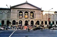
芝加哥美術館正門
布魯克菲爾德動物園(Brookfield Zoo)正式名稱芝加哥動物園(Chicago Zoological Park)。建於1934年,以其大規模的開放式場地出名。
菲爾德自然史博物館(The Field Museum of Natural History)最早建立於1893年9月,至今該館已收集有兩千多萬種生物及人文標本,每年組織有大量的展覽、研究和教育項目,館內的自然史圖書館藏書達25萬冊。
作家卡爾·山柏格(Carl Sandburg)、作家恩尼斯特·海明威(Ernest Hemingway)、廣播電視喜劇演員克·班尼(Jack Benny)、女詩人關朵琳·布魯克絲(GwendolynBrooks)、南京大屠殺時保護平民的美國傳教士明妮·魏特琳、創意動畫家/迪士尼樂園創辦人華德·迪士尼(Walt Disney)、以及美國第四十任總統隆納·雷根(Ronald Reagan)。