共找到2條詞條名為科羅拉多州的結果 展開
- 美國州名
- 睡蓮品種
科羅拉多州
美國州名
科羅拉多州(英語:Colorado)是美國西部的一州,東接堪薩斯州,南界俄克拉何馬州和新墨西哥州,西鄰猶他州,北與懷俄明州和內布拉斯加州接壤。該州首府兼最大城為丹佛。
科羅拉多州是以西班牙語“Colorado”命名的,意為“帶點紅色的”,估計這可能指的是該地區紅色的砂岩地層或是科羅拉多河兩岸的赭紅色景觀。
科羅拉多州州樹為雲杉,州花為薰衣草,州鳥為雲雀。
州徽
該州在美國地圖位置
主要城鎮:丹佛、奧羅拉、布頼頓、恩格爾伍德、萊克伍德、阿斯彭、博爾德、科羅拉多斯普林斯、柯林斯堡、大章克申、韋爾。路易斯安那購買協議取得該州東部大片土地。1806年派克斯攀登了以其名字命名的山峰(派克斯峰)。1859年派克斯峰發現金礦,掘金者蜂擁而至。1876年美國獨立100周年時建州,故有“百年州”之稱,成為美國第38州。
| County | FIPS code | County seat | Established | Formed from | Etymolgy | Population | Area | Map | |
| Adams County | 001 | Brighton | 1902-11-15 | Split fromArapahoe County. | Named in honor ofAlva Adams, the 5th, 10th, and 14thGovernorof the State of Colorado. | 441,603 | 1,182.29sqmi (3,062km) | ||
| Alamosa County | 003 | Alamosa | 1913-03-08 | Split fromCostilla CountyandConejos Countycounties. | Named for thecottonwood treeswhich grow along theRio Grandeand its tributaries.Alamosais a Spanish word for acottonwood grove. | 15,445 | 723.21sqmi (1,873km) | ||
| Arapahoe County | 005 | Littleton | 1861-11-01 | Created as one of the 17 original counties of theTerritory of Colorado. Renamed South Arapahoe County for the five months from November 15, 1902 to April 11, 1903. | Named for predecessorArapahoe County, Kansas Territory, which in turn was named for theArapaho NationofNative Americans. | 572,003 | 804.41sqmi (2,083km) | ||
| Archuleta County | 007 | Pagosa Springs | 1885-04-14 | Split fromConejos County. | Named in honor ofColorado State SenatorAntonio D. Archuleta. | 12,084 | 1,354.53sqmi (3,508km) | ||
| Baca County | 009 | Springfield | 1889-04-16 | Split fromLas Animas County. | Named in honor of pioneer andColorado territorial legislatorFelipe Baca. | 3,788 | 2,558.48sqmi (6,626km) | ||
| Bent County | 011 | Las Animas | 1870-02-11 | Split fromHuerfano Countyand former Cheyenne and Arapaho tribal land. | Named in honor of frontier traderWilliam Bent. | 6,499 | 1,541.07sqmi (3,991km) | ||
| Boulder County | 013 | Boulder | 1861-11-01 | Created as one of the 17 original counties of theTerritory of Colorado. | Named for the abundance ofgranitebouldersalongBoulder Creek. | 294,567 | 740.48sqmi (1,918km) | ||
| City and County of Broomfield | 014 | Broomfield | 2001-11-15 | Split fromBoulder,Adams,Jefferson, andWeldcounties and reorganized as aconsolidated city and county. | Named for thebroom cornthat was formerly grown in the area. | 55,889 | 33.57sqmi (87km) | ||
| Chaffee County | 015 | Salida | 1879-02-10 | Split fromCarbonate County. | Named in honor ofJerome Bunty Chaffee, one ofColorado's first twoU.S. Senatorsfrom 1876 to 1879. | 17,809 | 1,014.12sqmi (2,627km) | ||
| Cheyenne County | 017 | Cheyenne Wells | 1889-03-25 | Split fromElbertandBentcounties. | Named for theCheyenne NationofNative Americans. | 1,836 | 1,781.90sqmi (4,615km) | ||
| Clear Creek County | 019 | Georgetown | 1861-11-01 | Created as one of the 17 original counties of theTerritory of Colorado. | Named forClear Creekwhich originates in the county. | 9,088 | 396.53sqmi (1,027km) | ||
| Conejos County | 021 | Conejos | 1861-11-01 | Guadalupe County, one of the 17 original counties of theTerritory of Colorado, was renamedConejos Countyafter six days on November 7, 1861. | Named for thecottontail rabbitsin the area.Conejosis a Spanish word forrabbits. | 8,256 | 1,290.22sqmi (3,342km) | ||
| Costilla County | 023 | San Luis | 1861-11-01 | Created as one of the 17 original counties of theTerritory of Colorado. | Named for the Costilla River.Costillais a Spanish word meaning eitherlittle riborfurring timber. | 3,524 | 1,229.38sqmi (3,184km) | ||
| Crowley County | 025 | Ordway | 1911-05-29 | Split fromOtero County. | Named in honor ofColorado State SenatorJohn H. Crowley. | 5,823 | 800.27sqmi (2,073km) | ||
| Custer County | 027 | Westcliffe | 1877-03-09 | Split fromFremont County. | Named in memory ofGeorge Armstrong Custer, (1839 - 1876), the U.S. Armycoloneldefeated and killed at theBattle of the Little Bighorn. | 4,255 | 739.24sqmi (1,915km) | ||
| Delta County | 029 | Delta | 1883-02-11 | Split fromGunnison County. | Named for the town ofDeltalocated at thedeltaof theUncompahgre River. | 30,952 | 1,149.44sqmi (2,977km) | ||
| City and County of Denver | 031 | Denver | 1902-11-15 | The originalArapahoeCounty Seatwas split fromArapahoe Countyand reorganized as aconsolidated city and county. | Named to curry favor withJames W. Denver,Governorof theTerritory of Kansasfrom 1857 to 1859. | 600,158 | 155.66sqmi (403km) | ||
| Dolores County | 033 | Dove Creek | 1881-03-04 | Split fromOuray County. | Named for theDolores River, which was originally namedel Rio de Nuestra Senora de los Dolores, which is Spanish forthe River of our Lady of Sorrows. | 2,064 | 1,076.93sqmi (2,789km) | ||
| Douglas County | 035 | Castle Rock | 1861-11-01 | Created as one of the 17 original counties of theTerritory of Colorado. | Named in honor ofStephen Arnold Douglas, (1813 - 1861),U.S. SenatorfromIllinoisfrom 1847 to 1861. | 285,465 | 842.30sqmi (2,182km) | ||
| Eagle County | 037 | Eagle | 1883-02-11 | Split fromSummit County. | Named for theEagle Riverwhich originates in the county. | 52,197 | 1,700.76sqmi (4,405km) | ||
| El Paso County | 041 | Colorado Springs | 1861-11-01 | Created as one of the 17 original counties of theTerritory of Colorado. | Named forUte Passin the county.El pasois a Spanish expression forthe pass. | 622,263 | 2,128.60sqmi (5,513km) | ||
| Elbert County | 039 | Kiowa | 1874-02-02 | Split fromDouglas County. | Named in honor ofSamuel Hitt Elbert, the sixthGovernorof theTerritory of Colorado. | 23,086 | 1,849.08sqmi (4,789km) | ||
| Fremont County | 043 | Cañon City | 1861-11-01 | Created as one of the 17 original counties of theTerritory of Colorado. | Named in honor ofJohn Charles Frémont(1813 - 1890), the explorer, U.S. Army general, andU.S. SenatorfromCalifornia. | 46,824 | 1,533.09sqmi (3,971km) | ||
| Garfield County | 045 | Glenwood Springs | 1883-02-10 | Split fromSummit County. | Named in honor ofJames Abram Garfield(1831 - 1881), the twentiethPresident of the United States. | 56,389 | 2,958.23sqmi (7,662km) | ||
| Gilpin County | 047 | Central City | 1861-11-01 | Created as one of the 17 original counties of theTerritory of Colorado. | Named in honor ofWilliam Gilpin, the firstGovernorof theTerritory of Colorado. | 5,441 | 150.15sqmi (389km) | ||
| Grand County | 049 | Hot Sulphur Springs | 1874-02-02 | Split fromSummit County. | Named for theGrand Riverwhich originates in the county. The Grand River was renamed theColorado Riverin 1921, but the county retains the original name. | 14,843 | 1,868.53sqmi (4,839km) | ||
| Gunnison County | 051 | Gunnison | 1877-03-09 | Split fromLake County. | Named in honor ofJohn Williams Gunnison, the U.S. Army captain who explored the region. | 15,324 | 3,259.22sqmi (8,441km) | ||
| Hinsdale County | 053 | Lake City | 1874-02-10 | Split fromLake,Conejos, andCostillacounties. | Named in honor of George Aaron Hinsdale, a Lieutenant Governor of theTerritory of Colorado. | 843 | 1,123.35sqmi (2,909km) | ||
| Huerfano County | 055 | Walsenburg | 1861-11-01 | Created as one of the 17 original counties of theTerritory of Colorado. | Named forHuerfano Butte, a solitary volcanic plug.Huerfanois a Spanish word meaningorphan. | 6,711 | 1,592.37sqmi (4,124km) | ||
| Jackson County | 057 | Walden | 1909-05-05 | Split fromLarimer County. | Named in honor ofAndrew Jackson(1767 - 1845), the seventhPresident of the United States. | 1,394 | 1,619.75sqmi (4,195km) | ||
| Jefferson County | 059 | Golden | 1861-11-01 | Created as one of the 17 original counties of theTerritory of Colorado. | Named for its extralegal predecessor county,Jefferson County, Jefferson Territory, which in turn was named in honor ofThomas Jefferson(1743 - 1826), the author of theDeclaration of Independenceand the thirdPresident of the United States. | 534,543 | 772.85sqmi (2,002km) | ||
| Kiowa County | 061 | Eads | 1889-04-11 | Split fromBent County. | Named for theKiowa NationofNative Americans. | 1,398 | 1,785.90sqmi (4,625km) | ||
| Kit Carson County | 063 | Burlington | 1889-04-11 | Split fromElbert County. | Named in honor ofChristopher Houston "Kit" Carson, the famous frontier scout and soldier. | 8,270 | 2,162.43sqmi (5,601km) | ||
| La Plata County | 067 | Durango | 1874-02-10 | Split fromLakeandConejoscounties. | Named for the manysilverdeposits in the area.La platais a Spanish expression forthe silver. | 51,334 | 1,700.44sqmi (4,404km) | ||
| Lake County | 065 | Leadville | 1861-11-01 | Created as one of the 17 original counties of theTerritory of Colorado. RenamedCarbonate Countyfor the two days from February 8–10, 1879. | Named for theTwin Lakesin the county. | 7,310 | 383.55sqmi (993km) | ||
| Larimer County | 069 | Fort Collins | 1861-11-01 | Created as one of the 17 original counties of theTerritory of Colorado. | Named in honor ofWilliam Larimer, a pioneer entrepreneur. | 299,630 | 2,631.75sqmi (6,816km) | ||
| Las Animas County | 071 | Trinidad | 1866-02-09 | Split fromHuerfano County. | Named for theAnimas River, which was originally namedel Rio de las Animas Perdidas, which is Spanish forthe River of the Souls in Purgatory. | 15,507 | 4,773.27sqmi (12,363km) | ||
| Lincoln County | 073 | Hugo | 1889-04-11 | Split fromElbertandBentcounties. | Named in honor ofAbraham Lincoln(1809 - 1865), the sixteenthPresident of the United States. | 5,467 | 2,585.21sqmi (6,696km) | ||
| Logan County | 075 | Sterling | 1887-02-25 | Split fromWeld County. | Named in honor ofJohn Alexander Logan(1826 - 1886), a U.S. Army general andU.S. SenatorfromIllinois. | 22,709 | 1,845.31sqmi (4,779km) | ||
| Mesa County | 077 | Grand Junction | 1883-02-14 | Split fromGunnison County. | Named for themesaformations which are widespread through the area. | 146,723 | 3,345.69sqmi (8,665km) | ||
| Mineral County | 079 | Creede | 1893-03-27 | Split fromHinsdale,Rio Grande, andSaguachecounties. | Named from the plentifulmineraldeposits found in the area. | 712 | 878.16sqmi (2,274km) | ||
| Moffat County | 081 | Craig | 1911-02-27 | Split fromRoutt County. | Named in honor of railroad pioneerDavid H. Moffat. | 13,795 | 4,755.86sqmi (12,318km) | ||
| Montezuma County | 083 | Cortez | 1889-04-16 | Split fromLa Plata County. | Named in honor ofAztecleaderMoctezuma II. Ruins in the area were once thought to be Aztec. | 25,535 | 2,035.80sqmi (5,273km) | ||
| Montrose County | 085 | Montrose | 1883-02-11 | Split fromGunnison County. | Named for the town ofMontrose, which in turn was probably named from the novelA Legend of Montrose, published in 1819 byWalter Scott. | 41,276 | 2,246.43sqmi (5,818km) | ||
| Morgan County | 087 | Fort Morgan | 1889-02-19 | Split fromWeld County. | Named for oldFort Morgan, which in turn was named in honor of U.S. Army ColonelChristopher A. Morgan. | 28,159 | 1,293.83sqmi (3,351km) | ||
| Otero County | 089 | La Junta | 1889-03-25 | Split fromBent County. | Named in honor ofMiguel A. Oteroof the prominent Otero family of theSouthwest. | 18,831 | 1,267.66sqmi (3,283km) | ||
| Ouray County | 091 | Ouray | 1877-01-18 | Split fromHinsdaleandLakecounties. RenamedUncompaghre Countyfor four days from 1883-02-27, to 1883-03-02. | Named in honor ofOuray, aUteNative Americanleader. | 4,436 | 542.30sqmi (1,405km) | ||
| Park County | 093 | Fairplay | 1861-11-01 | Created as one of the 17 original counties of theTerritory of Colorado. | Named forSouth Parkwhich occupies most of the county. | 16,206 | 2,209.36sqmi (5,722km) | ||
| Phillips County | 095 | Holyoke | 1889-03-27 | Split fromLogan County. | Named in honor of R.O. Phillips, secretary of the Lincoln Land Company, which sold farmsteads in the area. | 4,442 | 688.30sqmi (1,783km) | ||
| Pitkin County | 097 | Aspen | 1881-02-23 | Split fromGunnison County. | Named in honor ofFrederick Walker Pitkin, the secondGovernorof the State of Colorado. | 17,148 | 970.37sqmi (2,513km) | ||
| Prowers County | 099 | Lamar | 1889-04-11 | Split fromBent County. | Named in honor of John W. Prowers, a pioneer of theArkansas Rivervalley. | 12,551 | 1,645.37sqmi (4,261km) | ||
| Pueblo County | 101 | Pueblo | 1861-11-01 | Created as one of the 17 original counties of theTerritory of Colorado. | Named for historic town ofPueblo.Pueblois a Spanish word meaningvillageorpeople. | 159,063 | 2,396.77sqmi (6,208km) | ||
| Rio Blanco County | 103 | Meeker | 1889-03-25 | Split fromGarfield County. | Named for theWhite River, which was originally namedRio Blancoin Spanish. | 6,666 | 3,226.24sqmi (8,356km) | ||
| Rio Grande County | 105 | Del Norte | 1874-02-10 | Split fromCostilla CountyandConejos Countycounties. | Named for theRio Grande, which flows through the area. | 11,982 | 913.10sqmi (2,365km) | ||
| Routt County | 107 | Steamboat Springs | 1877-01-29 | Split fromGrand County. | Named in honor ofJohn Long Routt, the firstGovernorof the State of Colorado. | 23,509 | 2,362.11sqmi (6,118km) | ||
| Saguache County | 109 | Saguache | 1866-12-29 | Split fromLakeandCostillacounties. | Name comes from aUte languagenoun meaning "sand dunes". | 6,108 | 3,168.32sqmi (8,206km) | ||
| San Juan County | 111 | Silverton | 1876-01-31 | Split fromLake County. | Named for theSan Juan RiverandSan Juan Mountains, which in turn were named forSaint John the Evangelist. | 699 | 388.99sqmi (1,007km) | ||
| San Miguel County | 113 | Telluride | 1883-03-02 | Split fromSan Juan County. | Named for theSan Miguel RiverandSan Miguel Mountains, which in turn were named forSaint Michael the Archangel. | 7,359 | 1,290.76sqmi (3,343km) | ||
| Sedgwick County | 115 | Julesburg | 1889-04-09 | Split fromLogan County. | Named for Fort Sedgwick, which, in turn, was named for U.S. Army GeneralJohn Sedgwick(1813 - 1864). | 2,379 | 548.83sqmi (1,421km) | ||
| Summit County | 117 | Breckenridge | 1861-11-01 | Created as one of the 17 original counties of theTerritory of Colorado. | Named for the many highmountain summitsin the area. | 27,994 | 618.92sqmi (1,603km) | ||
| Teller County | 119 | Cripple Creek | 1899-03-23 | Split fromEl PasoandFremontcounties. | Named in honor ofHenry Moore Teller, aU.S. SenatorfromColoradoandUnited States Secretary of the Interior. | 23,350 | 558.58sqmi (1,447km) | ||
| Washington County | 121 | Akron | 1887-02-09 | Split fromWeld County. | Named in honor ofGeorge Washington(1732 - 1799), the firstPresident of the United States. | 4,814 | 2,522.90sqmi (6,534km) | ||
| Weld County | 123 | Greeley | 1861-11-01 | Created as one of the 17 original counties of theTerritory of Colorado. | Named in honor of Lewis Ledyard Weld, the first Secretary of theTerritory of Colorado. | 252,825 | 4,013.84sqmi (10,396km) | ||
| Yuma County | 125 | Wray | 1889-03-15 | Split fromWashington County. | Named for theQuechan (Yuma) NationofNative Americans. | 10,043 | 2,369.61sqmi (6,137km) |
州旗
科羅拉多州盛產礦產,以金、銀。現以鉬、鈾、鋅、釩、銅、鉛、石油、煤和天然氣為主。鉬產量居全國首位。
科羅拉多州
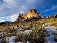
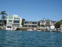
科羅拉多州自然風光
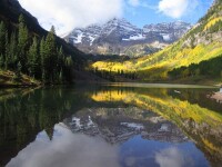
主要旅遊景點:岩石山國家公園、科羅拉多國家歷史文物、恐龍國家歷史文物、大的沙丘國家歷史文物和自然保護區、盛大Mesa 國家森林、派克國家森林、羅斯福國家森林、聖·伊莎貝爾國家森林、白色河國家森林、西部麋自然保護區。
科羅拉多州
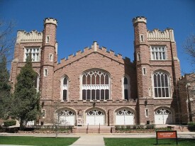
州立大學:科羅拉多大學、科羅拉多大學圓石市分校、科羅拉多大學科羅拉多泉分校、科羅拉多大學丹佛分校、科羅拉多州立大學、科羅拉多礦業學院、北科羅拉多大學、亞當斯州立學院、科羅拉多西方州立學院、南科羅拉多大學、路易斯堡學院、科羅拉多技術學院、大都會州立學院、美國空軍軍官學校。
私立大學:丹佛大學(University of Denver)、洛雷多高原學院、瑞吉斯學院、科羅拉多學院。
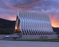
美國空軍軍官學校
1984年1月23日,科州與湖南省建立友好省州關係;科州的普韋布洛市與山東濰坊市建立友好城市關係;丹佛市與昆明市於1986年5月15日建立友好城市關係;博爾德與拉薩於1987年4月10日建立友好城市關係,美方於1989年11月14日無故中止。
科羅拉多州

喬治·伽莫夫
約翰·Q·威爾森(James Q. Wilson , 1931–2012):政治科學學者,以公共管治方面的研究最為知名
尼古拉·特斯拉(1856–1943):電機發明家、工程師
露絲·韓德爾(Ruth Handler,1916-2002):芭比玩偶的發明人
威拉得·利比(1908-1980):放射性碳定年法的發明人,諾貝爾化學獎
范朋克(1883-1939):電影演員
傑克·丹姆西(Jack Dempsey,1895-1983):世界重量級拳擊冠軍
約翰·丹佛(1943-1997):民歌歌手
喬治·伽莫夫(1904-1968):物理學家、宇宙學家、科普作家,熱大爆炸宇宙學模型的創立者
赫伯特·克勒默(1928-):諾貝爾物理獎得主,以半導體的研究為主
基本信息
- 中文名
- 科羅拉多州
- 外文名
- Colorado -- CO
- 面積
- 269997平方公里
- 人口
- 4753,377
- 氣候類型
- 年降水量平均僅406毫米。
- 著名景點
- 落磯山國家公園、丹佛自然歷史博物館、普埃布羅水庫(PUEBLO RESERVOIR)、丹佛動物園、CURECANTI遊樂區、美國空軍學院、MESA VERDE國家公園、ROYAL GORGE、國立恐龍紀念館、科羅拉多州國家紀念碑
- 地理位置
- 位於美國落基山區
- 政府駐地
- 丹佛市
- 機場
- 市花市樹
- 州花為薰衣草,州樹為雲杉
- 著名學校
- 科羅拉多大學,科羅拉多大學丹佛分校,科羅拉多州立大學
- 著名人物
- 埃里克·康奈爾、尼古拉·特斯拉、威拉得·利比
- 地方特產
- 小麥、甜菜
- 知名產業
- 鉬,錫,釩,鎢及鈾
- 州長
- 行政區類別
- 州
- 參議員
- 馬克·尤德爾,麥克·班尼
- 所屬地區
- 美國西南